10,173

The right bank of the Vltava – Rašín Embankment with its busy river traffic. In the background from the left: Jirásek Bridge, Šítkovská Water Tower in front of the Mánes building, and the Dancing House. | Photo: Diego F. Parra, Public domain, www.pexels.com.
Published: May 1, 2024 | Autor: admin.
Prague is already preparing for an influx of tourists, and the riverbank promenade along Rašín Embankment with its many boats is among the most popular. However, a great walk can also be enjoyed along the right bank of the Vltava from Hlávka Bridge toward the city center.
Route no. 1 on the map marks the path. The numbered points have no particular meaning; they are used only to ensure the route stays along the Vltava. Otherwise, mapy.cz tends to show the route along the road above the embankment or even further away.
The route can also begin at Libeň Bridge. It follows the water, but in the middle of this extended section you’ll have to go around a concrete plant, which holds little tourist interest. Alternatively, you can start from the Štvanice footbridge (which mapy.cz has not yet included in its aerial view), and from there the concrete plant is no longer in the way.
Thanks to the new footbridge (points 4 and 5 on map no. 2), you can also enjoy reaching the start of the main route by walking through Štvanice Island. Along the water and tennis courts or past the central tennis stadium – there are several options.
Whether you arrive at the main start of the route from Libeň Bridge or the Štvanice footbridge and include Štvanice Island or not, in any case you will pass under the Negrelli Viaduct.
The more comfortable riverside promenade, however, starts only at Hlávka Bridge and runs along the Těšnov Tunnel, with the Ministry of Transport of the Czech Republic behind it. During the communist regime, the tunnel was nicknamed “Husák’s silence”. Across the Vltava, the restaurant in the Brussels Pavilion will be “looking” at you from Letná Park.

The Czechoslovak Pavilion (actually a restaurant) from the 1958 World Expo in Brussels, relocated to Letná Park. | Photo: Miroslava Fišerová – Own work, CC BY-SA 4.0, https://commons.wikimedia.org.
During the previous regime, this part of the city along the Vltava was not particularly sought after. It didn’t have much to offer as a continuous experience. One of the only well-known places was the Botel Albatros. But that has long since changed. There are now several refreshment spots, pleasant places to sit, and beautiful views.

Botel Albatros seen from Štefánik Bridge. | Photo: ŠJů – own work, CC BY-SA 3.0, Wikimedia Commons.
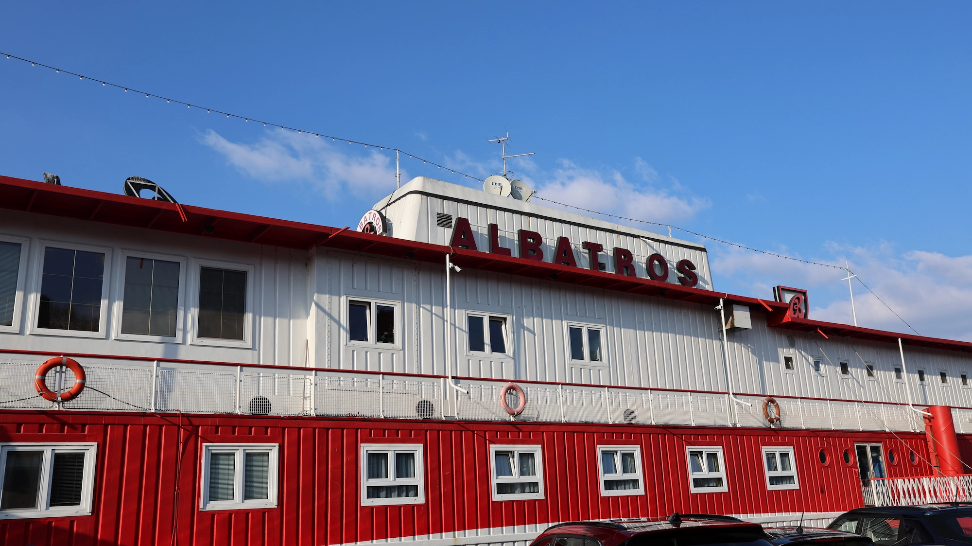
Botel Albatros now sports a fresh coat of paint. | Photo: admin.
In addition to restaurants, you’ll also find the Na Františku dock here, followed by Čech Bridge dock, where large flowerpots are filled with palm trees. As decoration, they seem somewhat exotic and out of place in Prague. The water surface of the Vltava, Prague Castle and the Petřín Lookout Tower in the distance, and palm trees on the bank – but it appears they thrive here. From Ludvík Svoboda Embankment, you’ll cross unnoticed onto Dvořák Embankment, and on the opposite bank you’ll see the rear of the Office of the Government of the Czech Republic.
Continuing on, you’ll reach Jan Palach Square, home to the famous Rudolfinum concert hall, the sadly known Faculty of Arts of Charles University, and the Academy of Arts, Architecture and Design in Prague (UMPRUM).
And that’s where this basic route description ends.
Video
The aim of this article is not to list and describe all the attractions along the route. After all, anyone can find most of them on the map themselves. And depending on your interest and time, you can visit them. But the idea is to show that you can follow the Vltava riverbank for a long stretch away from the main tourist routes, sometimes right along the embankment, and still not miss Prague’s highlights. You can even find places to rest and sit by the water (or even on the water), lie in the grass, see love and luck locks on fences, encounter surprise entertainment with small musical performances, walk through the renovated arcade from Křižovnické Square to Novotného Footbridge, and see unique vessels on the Vltava, historic cars on the road, or horse-drawn carriages.
All this is shown briefly in the video, which ends just before Slovanský Island and the Žofín Palace.
If someone continues along the Vltava, they will reach Rašín Embankment with its bustling riverside area and several docks. And not just docks... You can even board a boat and sail to Slapy (or to Třebenice below the Slapy Dam), to the Prague Zoo, or all the way to Mělník.
So perhaps this article will inspire you to take a trip or walk – not too demanding or long – that can brighten your morning, afternoon, or even an entire day. It depends on how and from where to where you take it. All before the center of Prague becomes completely overwhelmed with tourists. By the end of May, expect the route to briefly run along Křižovnická Street and cross the heavily trafficked tourist path from Charles Bridge to Karlova Street. The mass of tourists in this part of Prague can often become nearly unbearable.
-
(recording length 3:08)
Pravý břeh Vltavy v centru Prahy

Weather forecast for the trip area
The common finish/start of both routes is exactly in the middle of the map.
Terrain Difficulty
The route is flat and suitable for children and seniors.
In good weather, especially in the main tourist season, there may be more visitors in some sections (particularly in the second half of the route). Local residents may also rest and relax here from time to time.